2 new spots to watch in the Atlantic. 1 could bring rain to Florida soon
Published in Weather News
MIAMI — Despite Hurricane Humberto vanishing off the map and Post-Tropical Cyclone Imelda safely out to sea, there’s no breather for the Atlantic this October.
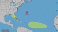
Thursday morning, the National Hurricane Center marked two new disturbances to watch — both with low chances of formation anytime soon.
The first is located smack dab over Florida, but forecasters only gave it a 10% chance of strengthening into a tropical depression or storm in the next two to seven days, and it doesn’t have a lot of support in the models.
The hurricane center said development may be slow to occur as it drifts northwestward across the state over the weekend, likely bringing rain whether it strengthens into a tropical depression or not.
The Miami office of the National Weather Service called for a rainy weekend ahead in Florida, and the coast is still facing a high rip current risk from the swells left behind by Hurricane Imelda.
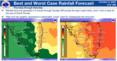
NWS called for a “best case scenario” of 2 to 3 inches of rain over the weekend along the coast of South Florida, and a “worst case scenario” of 4 to 6 inches of rain.
“Localized urban flooding will remain a concern over the next several days,” NWS warned Thursday morning.
The second disturbance is a tropical wave expected to roll off of the coast of Africa in the next day or two. From there, the hurricane center said, it’s expected to combine with another disturbance in the Atlantic ocean and “some slow development” is possible as it moves west.
As of Thursday’s 8 a.m. update, forecasters gave it no chance of strengthening in the next two days and a 20% chance of developing within the next seven days.
This system has more model support. The long-range storm models, including the European model, the American model and Google’s DeepMind AI-powered storm models, all suggest some level of strengthening as the system moves west over the next few days toward the eastern Caribbean islands.
“In general, the forecasts that predict a strong storm or a hurricane bend the system north into the open ocean. But it's too early to rely on any forecasts at this point. We'll have to see what shape the system is in when it's over the tropical Atlantic next week,” wrote Bryan Norcross, hurricane specialist at FOX Weather, on his blog Thursday morning.
The next name on the storm list is Jerry.
©2025 Miami Herald. Visit miamiherald.com. Distributed by Tribune Content Agency, LLC.


Comments