No hurricane landfalls so far this year. Here's why, and what to expect next
Published in Weather News
By the end of September, the U.S. usually has at least one hurricane landfall, if not several.
Not so in 2025. Four hurricanes have formed so far in the Atlantic season and none have hit the U.S.
In fact, this is the first hurricane season in 10 years that no hurricanes have made landfall in the U.S. through the end of September, points out AccuWeather’s hurricane expert Alex DaSilva.
Where have all the storms gone, and why?
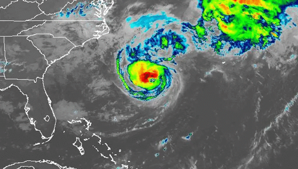
The hurricanes that did form were strong — Erin, Gabrielle and Humberto all reached Category 4 strength, and Humberto reached Category 5.
But they’ve all arced north, away from the U.S. east coast, eventually U-turning back out into the Atlantic.
This is due in part to the Bermuda High, a semi-permanent high-pressure system that shifts position and size over the Atlantic.
The Bermuda High blocks hurricanes from spinning north as they travel across the ocean. This can steer them into the U.S., or if the high backs off, the storm cuts north before it reaches the U.S.
“The Bermuda high has been a little bit further east this year, and a little on the weaker side overall. That’s allowed most of the storms to just go around the edge of it and head out to sea. It hasn’t bulged west too much this season,” DaSilva said.
Without steering forces, a tropical cyclone in the Atlantic will always turn to the right, because it is spinning counter-clockwise.
“The Bermuda High is extremely variable,” DaSilva said. “Sometimes it’s just sheer luck or not luck.” He said sometimes warm sea-surface temperatures near Europe can pull it east, allowing storms approaching the U.S. an easier turn away from land.
Another storm-steering force has been the jet stream. “Overall there’s been more dips in the jet stream over the east.” He said that creates a high-altitude wind from southwest that can collide with approaching storms, pushing that storm away from the U.S.
Dry air coming off Northern Africa has hindered storms, as has wind shear, both over the Atlantic and the Gulf.
Hurricane Humberto also did us a favor by pulling Hurricane Imelda away from the U.S. east coast.
As Humberto and Imelda paralleled each other, barreling toward the U.S., the rotational winds of Humberto, the larger system farther out to sea, pulled Imelda out to sea.
DaSilva thinks that if Humberto didn’t exist, Imelda would definitely have made landfall in the Carolinas.
Previous late-comers
Late-season hurricanes do occur:
Nov. 21, 1985: Hurricane Kate made landfall as a Category 2 storm in the Panhandle.
Oct. 29, 1998: Hurricane Mitch made landfall in Honduras, then again in Mexico on Nov. 4, and finally as a tropical storm in the Keys on Nov. 5.
Oct. 21, 2005: Category 4 Hurricane Wilma made landfall at Cozumel, Mexico, then made a U-turn and hit Florida’s southwest coast, at Cape Romano on Oct. 24.
Oct. 29, 2012: Hurricane Sandy did massive amounts of damage to New York City and the northeast, making landfall near Atlantic City, N.J., as a post-tropical cyclone.
Oct. 10, 2018: Category 5 Hurricane Michael crushed the Panhandle and was directly responsible for 16 deaths.
Will our luck hold out?
As for the next two weeks, DaSilva said he expects a tropical wave to roll off Africa some time between Oct. 5 to 8. It’s too early to tell what will come of it.
The Colorado State two-week hurricane season outlook predicts “above-normal activity” for the two weeks, and an above-average amount of Caribbean Accumulated Cyclone Energy in October and November.
As for the coming months, DaSilva said we are in the early phases of a La Niña, which should bring wind shear down, making storm formation easier in the next two months, particularly in the Gulf.
“Toward the middle of the month we’re going to have to watch the western Caribbean and southern Gulf,” DaSilva said.
The lack of storms in there has left the waters calm and thus hot. “The ocean heat content … is exceptionally high in the Gulf and western Caribbean,” he said.
“Those waters are untouched, so if you get a storm in there … we could be dealing with rapid intensification. There’s so much energy that’s in the ocean that has been untapped.”
_____
©2025 South Florida Sun Sentinel. Visit at sun-sentinel.com. Distributed by Tribune Content Agency, LLC.


Comments