Tropical Storm Gabrielle becomes 7th named storm of Atlantic season; NHC tracks 2 more systems
Published in Weather News
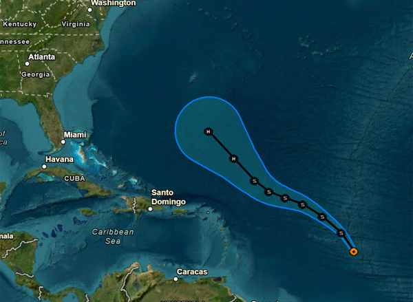
ORLANDO, Fla. — Tropical Storm Gabrielle formed Wednesday forecast to become a hurricane in the Atlantic, but there is no immediate threat to land, according to the National Hurricane Center, which was also tracking two more systems.
As of the NHC’s 11 a.m. EDT advisory, what had initially been Tropical Depression Seven earlier Wednesday grew into the season’s seventh named storm, located about 1,085 miles east of the Caribbean’s northern Leeward Islands with maximum sustained winds of 45 mph headed north-northwest at 22 mph.
“An erratic northwestward to west-northwestward motion at a reduced forward speed is anticipated across the tropical and subtropical central Atlantic during the next few days,” forecasters said.
Its forecast path keeps it away from land over the next five days.
“Little strengthening is anticipated over the next 48 hours as Gabrielle faces an unfavorable shear environment from an upper-level trough and a possible center re-formation, and the forecast intensity remains nearly steady through Friday,” forecasters said. “By this weekend, a more conducive environment is anticipated, which should allow for gradual intensification.”
Long-term projections has it growing into a Category 1 hurricane by Sunday, which would be only the second hurricane of the season. It could then be a threat to Bermuda.
“The development of this system breaks a nearly three-week streak of no tropical cyclones in the Atlantic basin during the peak of the hurricane season,” said NHC senior hurricane specialist John Cangialosi.
The NHC was also tracking two more systems in the eastern tropical Atlantic.
As of the 2 p.m. EDT tropical outlook, the closer of the two was a tropical wave near the Cape Verde Islands producing an area of disorganized showers and thunderstorms.
“Environmental conditions are only marginally conducive, and any development of this system should be slow to occur while it moves westward at 15 to 20 mph across the eastern and central portion of the tropical Atlantic,” forecasters said.
The system is expected to bring heavy rain to the Cape Verde Islands through Thursday.
The NHC gave it a 10% chance to develop in the next two days, and 20% chance in the next seven days.
Newly tracked on Wednesday was a tropical wave still over land but forecast to move off the coast of Africa by Friday.
“Some slow development of this system is possible as it moves west-northwestward across the eastern tropical Atlantic this weekend into early next week,” forecasters said.
The NHC gave it a 20% chance to develop in the next seven days.
The next names after Gabrielle would be Humberto and Imelda.
The climatological peak of the Atlantic hurricane season was on Sept. 10, but 60% of annual activity has historically happened after this date, the NHC stated.
With the new depression, the season has had only seven official storms. The most recent, Tropical Storm Fernand, petered out by the end of August.
The only hurricane had been Hurricane Erin, which grew into a massive Category 5 system with 160 mph winds but remained in the Atlantic without making landfall.
The National Oceanic and Atmospheric Administration in early August updated its season forecast to call for 13-18 named storms this year, of which five to nine would grow into hurricanes. Two to five of those would develop into major hurricanes of Category 3 or higher.
Hurricane season runs from June 1 to Nov. 30.
_____
©2025 Orlando Sentinel. Visit at orlandosentinel.com. Distributed by Tribune Content Agency, LLC.


Comments