NYC under first blizzard warning in 9 years, up to 17 inches of snow predicted
Published in News & Features
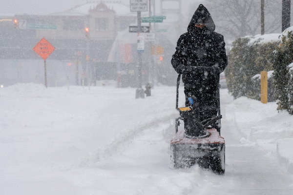
NEW YORK — New Yorkers only just freed from the snow and ice left by January’s monster storm will once again face winter’s wrath.
The National Weather Service on Saturday issued a blizzard warning across all five boroughs, as well as Long Island, the Lower Hudson Valley, southern Connecticut and much of New Jersey. The warning — the first of its kind since 2017 — has been put into effect from 6 a.m. Sunday until 6 p.m. Monday.
The upcoming storm comes courtesy of a growing nor’easter that could dump more than a foot of snow on the Big Apple and the rest of the tristate area. It could also bring “heavy blowing snow and winds gusting up to 55 mph,” resulting in treacherous whiteout conditions, forecasters said.
“Confidence is increasing in a major coastal winter storm that will bring significant snowfall and strong winds to New York City,” NYC Emergency Management wrote on social media Saturday morning. “Total snowfall is currently forecast around 13 to 17 inches, with higher totals possible in southern parts of the city.”
NYCEM later said there’s a “20-25% chance of a worst-case scenario” bringing up to 23 inches.
Flakes are expected to begin falling as early as 4 a.m. Sunday but be light until the early evening. Heavier snow is expected to roll in around 6 p.m. and rapidly increase, becoming its most intense overnight and Monday morning. The snow could easily exceed 1.5 inches per hour, with “potential bursts of 2-3 inches per hour,” NYCEM said.
Meteorologists have warned of extremely dangerous travel conditions for Monday commuters as areas of blowing snow could create “near-zero visibility,” while the “combination of gusty winds and heavy wet snow could bring down tree branches.”
Minor coastal flooding is also expected, “with a strong chance of moderate flooding along Jamaica Bay, Staten Island, the Battery, and parts of the Bronx and northern Queens,” officials said.
Those with air travel plans should be prepared for widespread flight cancellations, delays and ground stops.
“High winds, low visibility and the need to clear runways and de-ice aircraft will disrupt operations Sunday night through Monday, with ripple effects lasting into Tuesday or beyond,” NYCEM said.
As of early Saturday afternoon, nearly 70 flights into and out of JFK, LaGuardia and Newark airports had already been canceled for Sunday, according to flight tracking website FlightAware.
Forecasters predict the precipitation will taper off entirely by Monday afternoon, at which point New Yorkers will once again have to dig themselves out of the snow.
Temperatures will stay cold enough for it to stick through at least the middle of the week, before conditions begin to rebound. By the weekend, highs could reach the low 50s, with clouds giving way to some much-needed sun.
The city was walloped by a major winter storm at the end of January, which dumped more than 10 inches of snow in Central Park and resulted in the cancellation of thousands of flights.
In the weeks since, NYC and the surrounding areas have faced frigid temperatures, which has allowed for the white stuff to linger. Some of the plowed-back mountains of snow, which for weeks choked traffic on both sidewalks and streets, still remained on Saturday.
Meteorologists have said that any “small variations” in the storm’s track could drastically alter the predicted snowfall totals.
“The exact track of this storm, along with how quickly it strengthens, will determine how much snow falls in the mid-Atlantic and Northeast,” said Dan DePodwin, AccuWeather’s vice president of forecasting operations. “The supply of cold air is limited, and that could also affect snowfall totals.”
©2026 New York Daily News. Visit nydailynews.com. Distributed by Tribune Content Agency, LLC.


Comments