Florida's Gulf Coast could see a Cat 2 hurricane this week. Helene close to forming
Published in News & Features
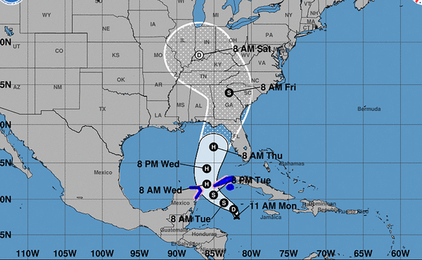
ORLANDO, Fla. — Florida’s Panhandle and Big Bend area could see a hurricane make landfall sometime on Thursday, potentially as a Category 2 or stronger.
Monday morning, the National Hurricane Center issued its first forecast track for a disturbance hovering west of Jamaica, now classified as potential tropical cyclone 9. The current forecast rack would take it between Mexico and Cuba, into the Gulf of Mexico and into Florida’s Gulf Coast in three days.
Mexico issued a tropical storm warning for the Yucatan Peninsula, and Cuba issued one for the Isle of Youth and Artemisia, as well as a hurricane watch for Pinar del Rio. Both spots could see up to four feet of storm surge and several inches of rain from the storm.
Gov. Ron DeSantis issued a state of emergency for 41 counties in Florida that could be affected by the future storm on Monday afternoon.
“Now is the time to make an emergency plan, know your evacuation zone, and be as prepared as possible for the storm,” he said in a statement on Twitter.
West coast on watch
Because the system has not formed yet and lacks a defined center, forecasters warned that the forecast was more uncertain than usual. They expect Helene to develop in the next day or two and then rapidly strengthen as it heads toward Florida.
In a briefing Monday morning, Jamie Rhone, deputy director of the hurricane center, urged Floridians to be prepared for a “potentially major hurricane” later this week.
“This is a classic case of don’t focus on the center of the cone, and don’t focus on the models. Why? Because this system is very large and is likely going to spread impacts well to the east,” he said.
“That means practically everybody along the Florida west coast all the way up to the big bend and Florida panhandle has to be on guard.”
South Florida could see rain, potentially heavy, beginning as soon as Wednesday and lasting into the weekend. Tropical-storm-force winds could reach the Florida peninsula as soon as Wednesday morning in the Keys.
Watches and warnings for swaths of the Florida coast could be issued as soon as Tuesday, Rhone said.
Rapid intensification likely
While Helene had still not officially formed a tropical depression as of the Monday 2 p.m. update, meteorologists said that was a good thing. Bill Karins, a meteorologist for NBC news, shared several graphs showing the high potential for Helene to rapidly intensify in the Gulf.
“The longer it takes to organize the better,” he wrote on Twitter.
Helene’s path forward is lined with some of the warmest waters in the Atlantic basin, which could fuel its growth into a strong hurricane. The first forecast called for Helen to top out with 110 mph sustained winds right before landfall, a strong Category 2 verging on Category 3.
The waters in the northeast Gulf are about 2 degrees Celsius warmer than average, posted Ben Noll, a meteorologist with New Zealand’s National Institute of Water & Atmospheric Research, on Twitter.
“It’s concerning from a potential intensity and moisture availability perspective!” he wrote.
©2024 Miami Herald. Visit at miamiherald.com. Distributed by Tribune Content Agency, LLC.


Comments