Florida's Gulf coast should prepare for Hurricane Helene this week; governor declares state of emergency
Published in News & Features
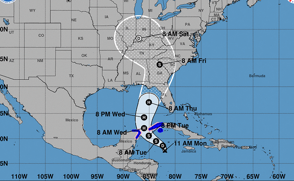
Forecasters warned residents along Florida’s Gulf coast of potential Hurricane Helene, which is expected to form in the next 48 hours and track toward an area somewhere between Tampa and Pensacola late in the week.
Because of the storm threat, Gov. Ron DeSantis on Monday afternoon issued a state of emergency in 41 Florida counties.
The storm is developing south of Cuba and should travel north into the Gulf of Mexico as it strengthens, according to the National Hurricane Center.
Forecasters expect the storm will become a hurricane by Wednesday morning as it passes between Cuba and the Yucatan Peninsula. It will then track to the northeast toward Florida’s panhandle.
There are now tropical storm warnings and hurricane watches issued for parts of Mexico’s Yucatan Peninsula and Cuba.
“Hurricane conditions are possible within the watch areas by early Wednesday. Tropical storm conditions are expected in the warning areas beginning on Tuesday,” said the NHC.
The system is currently located 110 miles south-southwest of Grand Cayman, moving north at 6 mph with maximum sustained wind speeds of 30 mph.
Various computer forecasting models — also known as spaghetti models — show Tampa to Pensacola, including Tallahassee, should be vigilant.
By Thursday, as the system approaches Florida’s panhandle, wind speeds could reach 110 mph, said the NHC. That would put the storm on the upper end of a Category 2 hurricane.
High water temperatures, which fuel hurricane formation, are present along the projected path of the storm, said University of Miami meteorologist Brian McNoldy on X. “The ocean heat content in the Gulf is *extremely* high, particularly inside the Loop Current, which future-Helene will pass over,” he wrote.
The NHC’s cone of probability currently includes Tampa and reaches into the western panhandle near Pensacola.
“Everyone along the Florida Panhandle and Big Bend region needs to be prepared for hurricane impacts,” said AccuWeather Lead Hurricane Expert Alex DaSilva, adding that the setup has the potential to become the strongest hurricane landfall in the U.S. so far this season.
The storm is expected to drop 4 to 8 inches of rain upon western Cuba and the Cayman Islands with isolated totals around 12 inches. The eastern Yucatan Peninsula should expect 2 to 4 inches of rain with isolated area with more than 6 inches.
Starting Wednesday, the Southeastern U.S. will receive heavy rainfall that should last through Friday.
Meanwhile, a tropical wave in the far eastern Atlantic could become a tropical depression, forecasters said. Gradual development of this system is possible as it moves west toward the central Atlantic.
As of 11 a.m. Monday, the disturbance has a 70% chance of developing in the next seven days, up from 30% on Saturday.
Experts at Colorado State University issued an updated two-week forecast Tuesday, calling for a normal of hurricane activity. The forecast says it is very unlikely there will be an above-normal amount of activity through the next two weeks.
Hurricane season runs from June 1-Nov. 30, but the height of storm production runs from mid-August into October.
©2024 South Florida Sun Sentinel. Visit at sun-sentinel.com. Distributed by Tribune Content Agency, LLC.


Comments