Parts of Central Florida under freeze warning as cold weather moves in for the long haul
Published in Weather News
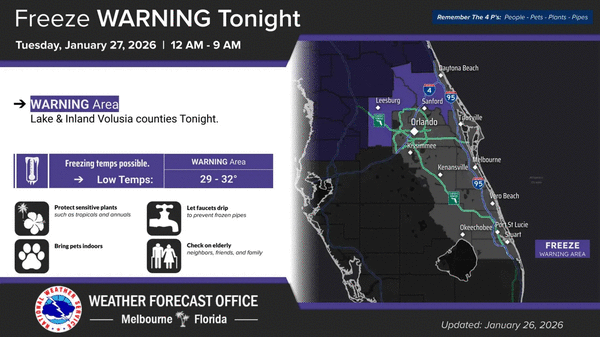
ORLANDO, Fla. — The National Weather Service in Melbourne has issued a freeze warning for parts of Central Florida for overnight into Tuesday morning with forecast temperatures expected to fall into the lower 30s.
The warning is in effect from midnight-9 a.m. for Lake County and interior Volusia County with some areas that could see the upper 20s.
The NWS suggests covering tender vegetation or bringing them indoors.
Most of the rest of the region is under a cold weather advisory from 1 a.m. to 9 a.m. because of cold temperature wind chills that will bring the feels-like temperatures into the 20s and 30s as an extended period of below-normal temperatures is forecast this week.
It covers Orange, Lake, Osceola, Seminole, Volusia, northern Brevard and inland Brevard counties as well as inland Indian River and Okeechobee counties.
Before the cold gets to Central Florida, highs will venture into the mid to upper 70s before dropping into the 40s before midnight.
The cold front moving through has with it a 30-50% chance for showers followed by breeze west-northwest winds in the afternoon. Boating conditions become hazardous by the evening.
A freeze watch has been issued for Greater Orlando, Osceola County, and points northward for Tuesday night.
“Confidence is high that below-normal temperatures will last for the next week to 10 days, if not longer. There is a low to moderate risk of much below-normal temperatures late this weekend or early next week,” the NWS stated.
------------
©2026 Orlando Sentinel. Visit at orlandosentinel.com. Distributed by Tribune Content Agency, LLC.


Comments