New model for forecasting wildfires could change how they're fought -- and save lives
Published in News & Features
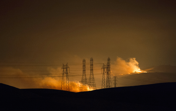
SAN JOSE, Calif. — When a lightning storm struck the parched Diablo mountain range in August 2020, igniting fires that turned the skies an apocalyptic shade of orange, the Governor’s Office activated current Oakland Fire Department Assistant Chief Christopher Foley to face the fire’s multiple fronts.
As the SCU fires spread through Alameda, Santa Clara and Contra Costa counties, the CZU Lightning Complex fires were raging in the Santa Cruz Mountains and San Mateo County. At the same time, the LNU Lightning Complex fires burned across the Bay Area’s wine country.
“Most of the state was burning,” said Foley, reflecting on how firefighting agencies from all over California assisted each other. “The fires down in Santa Cruz County and into Alameda County and then up the coast, they were all fairly simultaneous. We’re fortunate to be in the most robust mutual aid system in the country, if not the world. But it doesn’t take much for the system to get stripped. There is a limit to what we can do.”
Often fueled by dry lightning, multi-ignition wildfires continue to represent a severe threat and a significant challenge to firefighting efforts and firefighter safety. But a new model from the Lawrence Livermore National Laboratory and UC Irvine could be a crucial new tool — offering a new understanding of multi-ignition fires and the weather systems they create.
“We see a clear trend for those more extreme fires over western U.S. over the recent one to two decades. But why?” said Qi Tang, LLNL scientist and author of the study. “One possible reason is that those multi-ignition fires occur when there’s dry lightning. When there’s a system driving many lightnings, they can start fires in close-by areas.”
The study, published in the journal Science Advances, found that multi-ignition fires made up only 7% of the total number of fires between 2012 and 2023 but contributed to 31% of the burned area in the state.
Additionally, the study shows how, when separate fires combine, they become disproportionately destructive. They spread faster, last longer and create their own self-sustaining atmospheric conditions that perpetuate dry lightning.
The 2020 fires – the largest in Bay Area history in terms of acreage burned – resulted from separate ignitions from lightning strikes that rapidly escalated from roughly 25,000 acres on Aug. 18 to more than 137,000 acres on Aug. 20. Combined with other complex fires in San Mateo and Santa Cruz counties, and Lake and Napa counties, nearly 1 million acres burned across Bay Area counties. The fires strained CalFire wildfire fighting resources and forced urban firefighters from Oakland and surrounding areas to brave the burned terrain.
With a single ignition, firefighters can generally predict where the fire will go based on fuel and weather modeling, Foley said. Firefighters can then dig firebreaks or use controlled burns to eliminate vegetative fuel and stop the flames from spreading further, finishing containment using water or retardant at the front to cool the flames. But in the case of multi-ignition fires, the front could be traveling in multiple directions.
“If a fire is big enough,” as the 2020 Complex fires were, “it can create thunderstorm activity with severe downdrafts and outdrafts,” Foley said. “Anytime that that’s happening in multiple geographical areas, it’s going to definitely ratchet up the safety concerns.”
Researchers at UC Irvine used satellite data to track the development of multi-ignition fires. The data was shared with a team at LLNL to put into a simulation framework that “captures fire-triggered thunderstorms (pyrocumulonimbus) and their downstream effects,” according to LLNL. The simulation “connects the dots” of a fire’s behavior to create a big-picture understanding of how multi-ignition fires are moving, merging and forming regional atmospheric conditions.
“Those ones can generate pyrocumulonimbus clouds,” Tang said of the fire-induced thunderstorm clouds. “Those clouds can trigger lightning, so it’s very extreme, and can transport those fires’ smoke directly into the stratosphere. Some are even high to about 16 to 17 kilometers.”
While the modeling system remains in its research stage, Tang said he has ambitions to grow it from hypothetical to operational at California fire departments. Between 1990 and 2024, there have been 214 on-duty firefighter deaths in California, according to the U.S. Fire Administration. If adopted, the modeling system could be used before and during active fires to diagnose multiple fire fronts, determine how fires are likely to develop, and protect firefighters from dangerous situations.
“Having a modeling system to forecast that is important to know how you are going to fight those fires there, avoiding potential danger,” Tang said.
The modeling system has not yet been adopted by local or state fire agencies, Tang said, but he hopes to convince fire departments of the LLNL model’s capabilities in coming years. Tang said he would be meeting with NASA to discuss how a satellite may be utilized in the future to gather more data on multi-ignition fires to enhance the accuracy of the model. Foley said that accurate modeling of a multi-ignition fire’s growth may help incident commanders make more strategic decisions about where to send firefighting units.
“Let’s say a dry lightning event is coming into an area, and you know the ignition points. And we put these modeling layers on top of that and we know three of them are going to conceivably be the most severe,” Foley said. “We can put the bulk of our resources in those three areas, rather than having to get lucky with where we send people. Yeah, I think that tool will make an immeasurable difference.”
©2026 MediaNews Group, Inc. Visit at mercurynews.com. Distributed by Tribune Content Agency, LLC.


Comments