Hurricane Melissa, expected to be a major storm, creeps toward Jamaica and Cuba
Published in News & Features
The storm slowly crossing the Caribbean became Category 1 Hurricane Melissa Saturday afternoon as parts of the Caribbean prepared for heavy rains, flooding and landslides — if they weren’t already dealing with them.
And, Melissa’s expected to get much stronger as it approaches Jamaica, then Cuba.
What you need to know about Hurricane Melissa as of 5 p.m. Saturday
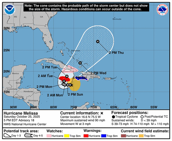
As of the 5 p.m. Saturday public advisory from the National Hurricane Center ...
Where Melissa is and where Melissa’s going: Melissa’s about 130 miles southeast of Jamaica’s capital city, Kingston, and 250 miles west-southwest of Port-Au-Prince, Haiti. The storm is moving west at 3 mph, up from 1 mph at the 2 p.m. update.
“A slow westward motion is expected tonight through the end of the weekend,” the hurricane center said. “A turn to the north and northeast is forecast on Monday and Tuesday. On the forecast track, the center of Melissa is expected to move near or over Jamaica during the weekend and early next week, and it could be near or over eastern Cuba by the middle of next week.”
Melissa’s size and strength: Melissa’s bringing maximum sustained winds of 90 mph, still a Category 1 storm on the Saffir-Simpson scale. Hurricane force winds extend 15 miles from the storm’s center, and tropical storm force winds extend 160 miles.
“Rapid intensification is forecast to continue over the next day or so and Melissa is forecast to become a major hurricane (Sunday) and is expected to still be a major hurricane when making landfall in Jamaica early next week,” the hurricane center said.”
Watches and warnings: Jamaica’s under a hurricane warning.
Hurricane watches are in effect for the Cuban provinces of Granma, Guantanamo, Holguin and Santiago de Cuba. Haiti’s southwest peninsula, from the border with the Dominican Republic to Port-Au-Prince, is under a hurricane watch and tropical storm warning, meaning they can expect tropical storm conditions within the next 36 hours.
On Saturday, the South and Grand’Anse regions of Haiti were both upgraded to red alerts by the National Disaster Risk Management System. Haitians were warned that the intensification of Melissa had increased the risks of flash floods and landslides. Haitians were asked to remain home, or to move to higher ground if they lived in a flood-prone area. They were also warned to “not cross rising water,” by any means.
Effects: Wind and rain are anticipated, but storm surge can do as much or more damage than both.
“Life-threatening storm surge is becoming more likely along the south coast of Jamaica later in the weekend or early next week,” the hurricane center said. “Peak storm surge heights could reach 9 to 13 feet above ground level, near and to the east of where the center of Melissa makes landfall. This storm surge will be accompanied by large and destructive waves. There is a potential for significant storm surge along the southeast coast of Cuba early next week.”
Winds could reach hurricane levels in Haiti later Saturday. Tropical storm-level winds are expected.
Being a slow-moving storm, Melissa’s expected to have a lot of time to dump a lot of rain on Haiti, Jamaica and the Dominican Republic. The hurricane center forecasts 15 to 30 inches, possibly even 40 inches, on parts of Jamaica and the southern Hispaniola island.
“Catastrophic flash flooding and landslides are probable across portions of southern Hispaniola and Jamaica,” the hurricane center said. “For eastern Cuba, total rainfall of 6 to 12 inches, with local amounts to 18 inches, are expected into Wednesday, resulting in life-threatening flash flooding and landslides.”
Haiti, Jamaica and Dominican Republic already feel the effects
The storm has already killed at least three people in Haiti this week during landslides attributed to the heavy storms. Haiti’s Office of Civil Protection said flooding of the Saint Martin River caused by heavy rains also destroyed a bridge in Saint Suzanne in the northeast region of Haiti.
Across Hispaniola, the island shared by Haiti and the Dominican Republic, residents are already seeing overnight flooding, downed trees and landslides in some areas. Given Melissa’s heavy rainfall, both countries are at an increased risk of experiencing catastrophic disasters even without a direct hit.
Residents of Kingston, Jamaica, were already dealing with floodwaters on Friday, as concerns are growing that the impact could be the worst since Hurricane Gilbert devastated the island in 1988. Parts of Jamaica are still recovering from last year’s Hurricane Beryl, which made landfall as a Category 4 storm.
In anticipation, a team of linesmen from the United States, Canada and St. Vincent arrived in the country this week to help restore power if needed. Also, countries such as The Bahamas have deployed flights to evacuate their students studying in Jamaica. Jamaica’s director of emergency management, Richard Thompson, said the island has 881 shelters prepared for residents to seek refuge.
In the Dominican Republic, 12 provinces are on red alert due to possible flooding of rivers, streams and ravines as well as flash floods and landslides. “People should refrain from crossing rivers, streams, and ravines with high water volumes,” the country’s disaster office warned. The office also said that five shelters have been activated: Two in the province of San Juan, one in San Cristóbal, one in San Pedro de Macorís, and one in the National District.
Water services for over 1 million users has also been affected, the office also noted.
At least nine Dominicans have had to be rescued from floodwaters: one from the waters of the Ozama River in the municipality of Monte Plata. Eight others were rescued on Luperón Avenue in the capital Santo Domingo after being trapped in their vehicles due to urban flooding.
Where is Melissa headed? Will it affect Florida?
Melissa’s movement had been slowed down by a pocket of wind shear that helped to balance out the storm-fueling effects of the warmer-than-average waters it is crossing.
But forecasters say the storm has started to recover from the shear and is becoming better structured. Because it’s moving slowly over very warm waters — the warmest in the Atlantic — conditions are ideal for rapid strengthening.
By early next week, Melissa is projected to strengthen into a powerful Category 4 hurricane. Forecasters expect it to reach near-peak intensity as it makes landfall and moves across Jamaica on Monday and Tuesday. However, the exact path of the storm’s center remains uncertain.
The hurricane center’s official forecast extends only through Wednesday, but long-range computer models — often referred to as spaghetti models — continue to indicate that Melissa will curve northeastward after leaving Cuba and avoid Florida. NHC forecasters say that a trough in the southeastern U.S. will weaken Melissa and push it northeast.
_____
©2025 Miami Herald. Visit miamiherald.com. Distributed by Tribune Content Agency, LLC.


Comments