Tropical Storm Melissa to reach major hurricane strength by Sunday; Florida told to stay vigilant
Published in News & Features
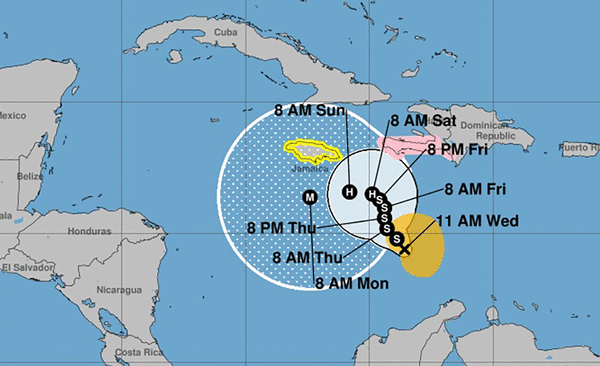
Forecasters said Wednesday that Hurricane Melissa will likely form by Saturday and intensify into a major Category 3 hurricane by Sunday.
Experts said South Florida should be keeping an eye on the long-range tracking models even though forecasters say the odds of U.S. impact are low.
The system, which was about 320 miles south-southwest of Port-au-Prince, Haiti, on Wednesday morning and moving west-northwest at 2 mph, had maximum sustained wind speeds of 50 mph, according to the National Hurricane Center. Tropical-storm-force winds extend outward up to 115 miles from the center.
Melissa is expected to make a gradual turn in the next few days to the northwest and then north-northwest. The current forecast track has the storm approaching the southwestern portion of Haiti and Jamaica this week.
“The exceptionally warm waters of the Caribbean will provide extra energy for Melissa to strengthen,” said AccuWeather Lead Hurricane Expert Alex DaSilva said. “This storm is expected to rapidly intensify into a major hurricane once it enters an area with less disruptive wind shear south of Jamaica.”
The farther west the storm travels the more likelihood it has of affecting Florida. The track at that point becomes quite murky, the hurricane center said. Some models have the storm whisking north and east, out into the Atlantic, while others suggest it could meander farther west, toward Central America before veering north.
The National Hurricane Center’s forecast “cone of uncertainty,” which shows the area of potential tracks over the next five days, is not much more than a circle, indicating very little movement.
The strength of the storm will determine the path. The stronger and taller it gets, the more likely it will be caught up in high-altitude winds pulling it to the northeast.
WPLG-TV hurricane expert Michael Lowry wrote in his Eye on the Tropics blog that, “with persistent wind shear keeping Melissa from quickly strengthening over the next few days, it appears the odds of it taking that early exit ramp are low. This means a slow drift westward toward Jamaica and the western Caribbean into early next week is most likely, with perhaps an eventual sharp turn toward eastern Cuba later next week.”
The uncertainty about the forecast leaves Florida open to some risk, said DaSilva.
“A dip in the jet stream over the Southeast U.S. and strong upper-level winds are expected next week, which should prevent movement toward the Gulf Coast states,” DaSilva said. “The risk of direct impacts on the U.S. is low at this time, but it cannot be ruled out.”
The so-called “spaghetti models,” which are computers that forecast the long-range track of a storm, show Melissa turning sharply to the north and northeast while it is south of Cuba. Where that turn happens will determine the threat level to Florida.
AccuWeather on Wednesday said “the U.S. concern for impacts will be in the Florida Peninsula, especially the lower portion of the Peninsula and the Keys.” AccuWeather also predicted that as the storm meanders in the Caribbean it could bring 12 to 30 inches of rain to portions of the Dominican Republic, Haiti, Jamaica.
Given the mountainous terrain of the islands, landslides and flash flooding are a serious concern.
Some forecasting models show Melissa reaching major hurricane status — Category 3 or higher — this weekend, with some showing Category 5 strength.
Melissa is the 13th named storm of the 2025 Atlantic hurricane season. Four hurricanes have formed so far. Of the 13 named Atlantic storms, only Tropical Storm Chantal has made a U.S. landfall.
Hurricane season runs through Nov. 30.
_____
©2025 South Florida Sun Sentinel. Visit at sun-sentinel.com. Distributed by Tribune Content Agency, LLC.


Comments