Thunderstorms, muggy weather ahead for Southern California thanks to Hurricane Priscilla
Published in News & Features
LOS ANGELES — Southern California could see some unseasonable rain and thunderstorms this week thanks to a hurricane moving north along the Mexican coast, according to the National Weather Service.
From Thursday to Saturday, the region's mountains, foothills and deserts could, again, see significant rainfall — this time because of Hurricane Priscilla, the National Weather Service warned. Last month, a similar pattern that pulled moisture north from Tropical Storm Mario triggered dangerous mudslides in the San Bernardino County mountains and flooding in the Inland Empire that killed one child.
However, local forecasts don't yet expect rainfall will be as dramatic this week. Widespread flood alerts were issued for Southern California as Mario moved north; that hasn't yet occurred this week.
But there is a chance that much of the Southland sees some precipitation, though the most concerning rainfall is expected further east into Arizona, Utah and Colorado. There, weather service officials have issued a hazardous weather outlook, warning of the potential for flash flooding, particularly in parts of Colorado and Utah.
In Southern California, it's the San Bernardino, Riverside and San Diego county mountains that have the highest chance to see heavy rainfall, mostly from thunderstorms that could develop over the area, said Sebastian Westerink, a National Weather Service meteorologist in San Diego. Depending on the strength of the storms, certain areas could get 1 to 2 inches of rainfall, he said, and there could be some flash flooding.
"It's really going to hit or miss in the mountains," Westerink said. The rest of Southern California, especially urban, coastal areas, will notice a shift in weather, but rainfall will be minimal, he said. Temperatures are expected to rise slightly across the region by Friday, but not too dramatically.
"It will mainly be cloudy region-wide; it will mainly be muggier," Westerink said. "We're forecasting generally less than a tenth of an inch of rain for the coastal basin."
South and east Los Angeles County are mostly likely to see rainfall, according to forecasts. Most of that moisture will move out of the Southland by the weekend, but some areas could still catch rain Saturday, Westerink said.
"Definitely by Sunday we should be done," he said.
But further east, heavy rains could continue through Tuesday, though the strongest storms are forecast Thursday through Saturday, according to the weather service.
Parts of Arizona, Utah, Colorado and New Mexico are preparing for the potential for flash floods beginning Thursday, with 2 to 4 inches of rain likely, and up to 6 inches possible, according to the National Hurricane Center.
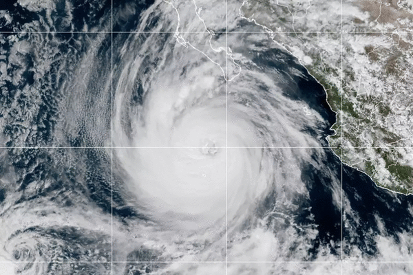
On Wednesday morning, Hurricane Priscilla was about 200 miles off the southern tip of Baja California, clocking winds around 75 mph, according to the latest update from the hurricane center. The storm is forecast to continue weakening over the next two days. Still, a tropical storm watch remained in effect for Baja California Sur, where effects from the storm were expected to begin Wednesday.
©2025 Los Angeles Times. Visit at latimes.com. Distributed by Tribune Content Agency, LLC.


Comments