Hurricane center ups chances tropical depression will form in Atlantic
Published in News & Features
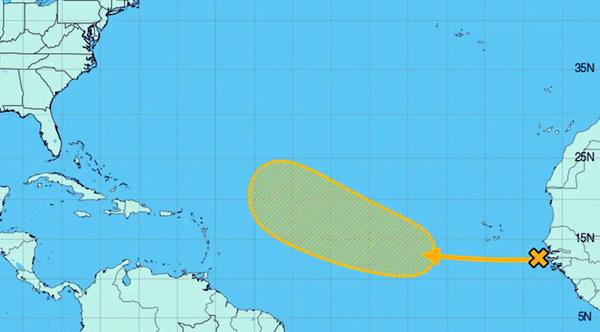
ORLANDO, Fla. — The National Hurricane Center on Friday increased the chances a tropical wave in the Atlantic will develop into the season’s next tropical depression or storm.
In the NHC’s 8 a.m. tropical outlook, the wave was near the west coast of Africa moving into the far eastern Atlantic producing disorganized showers and thunderstorms.
“Environmental conditions appear conducive for some gradual development of this system over the next several days,” forecasters said. “A tropical depression could form during the early to middle part of next week while it moves westward to west-northwestward at 10 to 15 mph over the eastern and central tropical Atlantic.”
The NHC gave it a 40% chance to develop in the next seven days, up from the 30% forecast on Thursday.
If it were to develop into a named storm, it could become Tropical Storm Gabrielle.
The climatological peak of the Atlantic hurricane season was on Sept. 10. but 60% of annual activity has historically happened after this date, the NHC stated.
So far the season has had only six named storms with the most recent, Tropical Storm Fernand, petering out by the end of August.
Only one of the six storms developed into a hurricane, Hurricane Erin, which grew into a massive Category 5 system with 160 mph winds, but remained in the Atlantic without making landfall.
The National Oceanic and Atmospheric Administration in early August updated its season forecast to call for 13-18 named storms this year, of which five to nine would grow into hurricanes. Two to five of those would develop into major hurricanes of Category 3 or higher.
Hurricane season runs from June 1 to Nov. 30.
---------
©2025 Orlando Sentinel. Visit at orlandosentinel.com. Distributed by Tribune Content Agency, LLC.


Comments