Colorado wildfires: 15,000-acre Turner Gulch fire is 9% contained, officials say
Published in News & Features
DENVER — After a week of rapid growth, crews battling the largest fire on Colorado’s Western Slope have finally begun to contain the flames, fire officials said.
Three of the four still-spreading fires in western Colorado were sparked July 10 during a lightning storm. The nearly 2,300-acre Sowbelly fire, which hasn’t grown since Monday, was started by the same storm.
The Sowbelly fire is 16% contained. To the west, fire officials announced Thursday that they’d been able to contain 9% of the 15,000-acre Turner Gulch fire’s perimeter.
No containment has been reported for the three other active fires.
Together, the wildfires across Montrose, Delta and Mesa counties had burned at least 23,718 acres as of Thursday morning, sending waves of smoke across the Western Slope.
The smoke has prompted multiple days of air quality advisories for the counties home to or near the fires.
The most recent advisory issued by the Colorado Department of Public Health and Environment will run from 9 a.m. Thursday through 9 a.m. Friday in Montrose, Delta and Mesa counties.
Thursday afternoon thunderstorms may produce strong winds and send the smoke in any direction, state health officials said.
An Ozone Action Day will also be active through at least 4 p.m. Thursday across the Front Range, including Denver, according to the department.
The air quality is expected to reach unhealthy levels for sensitive groups, officials said in the alert.
Sensitive groups include active adults and children, people with lung disease, people who spend a lot of time outside and people with heart disease or diabetes, according to state officials.
Symptoms of short-term exposure to unhealthy ozone levels include coughing, chest pain, difficulty breathing, or eye, nose and throat irritation. Long-term exposure has been linked to health issues like lung and heart disease.
Turner Gulch fire and Wright Draw fire near Gateway
The largest wildfire burning in Colorado, the Turner Gulch fire, has scorched more than 15,000 acres in Mesa County, fire officials said.
But, for the first time in the week it's been burning, fire officials announced Thursday that crews had been able to contain a small percentage of the fire's perimeter.
As of Thursday morning, the Turner Gulch fire was burning on 15,071 acres with 9% containment, according to fire officials. That containment is on the fire's southwest edge.
There's been minimal growth to the north of the fire, along Colorado 141, but fire officials have yet to declare that section officially contained, Operations Section Chief Brad Pietruszka said in a Thursday morning operations briefing.
The Turner Gulch fire makes up more than half the burn area from all the wildfires active on Colorado's Western Slope combined.
Extreme drought, steep terrain and hot, dry weather continue to challenge firefighters as the fire spreads, according to federal officials.
Those conditions are similar to those of the deadly South Canyon fire in 1994 near Glenwood Springs, which killed 14 firefighters, fire behavior analyst Glen Lewis said at a Wednesday night community meeting for the Turner Gulch and Wright Draw fires.
The Wright Draw fire, burning across Unaweep Canyon from the Turner Gulch fire, reached 448 acres Wednesday, fire officials said.
A Wright Draw size update was not available Thursday morning because Wednesday night cloud cover prevented crews from flying over the fire and completing the daily infrared scan, Pietruszka said.
Both lightning-sparked fires are burning along Colorado 141, which remains closed between 7.40 Road and 16.10 Road at mile marker 124, according to state transportation officials.
Land surrounding Colorado 141 from mile marker 120 to mile marker 134 and the Divide Forks Campground Area remain under mandatory evacuation orders Thursday, according to Mesa County sheriff’s officials. The stretch of state highway between mile markers 134 and 137 remains under pre-evacuation orders.
Deer Creek fire near Paradox
Increased cloud cover, light rain and less erratic winds helped slow the spread of a wildfire burning on the Utah-Colorado border Wednesday night, fire officials said.
The Deer Creek fire is burning on 15,655 acres of land between Colorado and Utah, according to a Thursday morning update from Utah fire officials.
Most of the active fire is spreading in eastern Utah, but flames have burned 1,746 acres of Bureau of Land Management land in Colorado, fire officials said.
It crept into Colorado near Paradox in Montrose County earlier this week, just north of Colorado 90.
Federal fire maps on Thursday showed that the wildfire was burning on a section of Colorado land more than two miles long and wide.
The wildfire was 7% contained Thursday, according to the fire maps, but that containment is on the Utah side of the fire and doesn't prevent it from spreading further into Colorado.
Fire crews are staged along Colorado 90 and in Paradox, fire officials said Thursday morning.
Rimrocker Trail at Q13 Road and Good Road, U5 Road at the turn for the Buckeye Reservoir and X2 Road all remain closed for fire activity, according to Montrose County officials.
Difficult weather conditions capable of producing rapid fire spread are forecast to continue over the next several days, with afternoon thunderstorms and wind gusts up to 60 mph possible, fire officials said.
South Rim fire near Montrose
The wildfire burning on more than 4,000 acres of land in Black Canyon of the Gunnison National Park has consumed 85% of the park's south rim, fire officials said.
As of Wednesday morning, the South Rim fire had burned 4,179 acres with no containment, according to federal fire maps.
Overnight cloud cover prevented crews from getting an updated infrared map of the fire, but those same clouds helped mitigate the fire's spread, Operations Section Chief Tyler Nathe said in a Thursday morning briefing.
"Not a whole lot of precipitation over the fire area, but with the cloud cover and milder conditions, we had a really good, mellow day across the fire," Nathe said.
Evening rain showers, higher humidity and lower temperatures helped slow the fire's growth overnight, according to the Rocky Mountain Area Complex Incident Management Team 3.
Mandatory evacuations remain in effect for nearby homes and trails, including the Bostwick Park area.
Black Canyon remains closed to the public with no timeline to reopen, and all campground reservations have been canceled for the rest of 2025.
A section north of U.S. 50 along Colorado 347 and an area between Rawhide Gulch and the Montrose Reservoir remain under pre-evacuation orders, according to a map created by Montrose County officials.
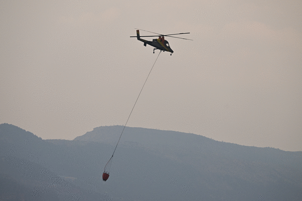
Resources fighting the fire Thursday include 458 people, 23 fire engines and five aircraft, including helicopters and scooper planes capable of picking up 1,412 gallons of water in 12 seconds.
Curecanti National Recreation Area is open to the public, but the Blue Mesa Reservoir remains closed so aerial crews can access and use the water, fire officials said.
©2025 MediaNews Group, Inc. Visit at denverpost.com. Distributed by Tribune Content Agency, LLC.


Comments