Forecasts for Hurricane Helene's path were uncannily accurate. Here's why
Published in News & Features
FORT LAUDERDALE, Fla. — There have been 11 named storms thus far this year, and the National Hurricane Center has been uncannily accurate in predicting their paths and strengths.
Tropical Storm Alberto spun up west of the Yucatan Peninsula and made landfall three days later in Tampico, Mexico, nearly exactly where the Hurricane Center said it would.
When Hurricane Beryl churned south of the Dominican Republic, its five-day cone of probability included Matagorda, Texas, 2,000 miles away. Six days later, Beryl made landfall in Matagorda, Texas.
Most of the other storms that made landfall, such as Francine, had similarly accurate forecasts.
“Steering for most of the storms this year has been pretty straightforward,” said University of Miami’s Andrew Todd Hazelton, a hurricane researcher who works with the NHC, and had been flying on hurricane hunter airplanes within Helene.
“That is something that varies from year to year,” he said, and noted that last year, Tropical Storm Philippe wandered all over the place east of the Caribbean before shooting up to Bermuda.
Forecasts for Hurricane Helene formed before the system even had a name, and they were right on target. Meteorologists accurately predicted the path, correctly projecting that it would shoot the gap between Cuba and the Yucatan Peninsula, then strengthen into a hurricane and steer to the right, directly to Florida’s Big Bend.
Three days later, the storm made landfall almost exactly where they said it would, in Apalachee Bay south of Tallahassee.
Hazelton said as part of his work at the NHC they’ve been using a new Hurricane Analysis and Forecast System (HAFS) and weaving it into their models. “It did well for this storm … the rapid intensification that it was showing did end up happening.”
AccuWeather, too, was very confident in Helene’s path, even five days out before it formed. “The idea was that there was always going to be this dip in the jet stream across the Mississippi Valley, and we knew that was going to favor the storm coming up into Florida,” said chief AccuWeather meteorologist Jonathan Porter. “The steering flow was very accurate. We were confident about the storm heading to the Big Bend region.”
“In this case, the steering factors were set,” Hazelton said. “There was a trough over the central U.S. Our models did a good job of handling the position of that. The NHC uses averages of good models, and tends to average out the errors.”
He said high pressure in the western Atlantic also kept the storm aimed at the Big Bend, instead of drifting east to Tampa, Orlando or Miami.
Predicting size and surge
One of Helene’s most startling factors was its size. Its tropical storm-force wind field grew to reach 345 miles from the center, a 690-mile-wide storm.
The wind field predictions, which drive storm surge predictions, were also uncannily accurate.
How did forecasters know it was going to be big and wide before it even formed?
AccuWeather’s Porter said that he and his team were able to predict the size of the storm because of two factors with strong historical trends.
Firstly, Helene formed in relation to the Central American Gyre, an area of low pressure with lots of loosely organized showers and thunderstorms. “When storms come of the gyre, they tend to have a broad circulation,” he said.
Secondly, “as Helene drew closer to the Gulf coast it interacted with another storm in the Mississippi Valley. When that happens, storms often intensify, and the wind field gets broader.”
At this time of year, the Central American Gyre offers lots of moisture, Hazelton said. There was so much moisture available for Helene that it resembled a typhoon in the Western Pacific, he said.
That size allowed for very accurate storm surge forecasts on the west coast. “This was gonna be a big surge producer, being such a large storm,” Porter said.
A broad storm with hundreds of miles of ocean to push up into land is going to affect a much more vast area than a narrow storm, and it’s going to pile the water up higher.
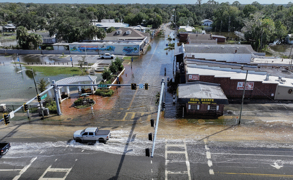
The Hurricane Center was calling for 10 to 15 feet of storm surge in the Big Bend region while Helene was still just a tropical storm south of Cuba. They projected that surge, though smaller, to extend nearly the entire length of Florida’s west coast. That’s exactly what happened.
Cedar Key south of the Big Bend was projected to get 10 to 15 feet of surge. The NOAA tide gauge there showed water levels there 10 feet higher than the normal tide during the storm.
“When I was flying last night (Thursday), I was amazed at how far out away from the center we were seeing flight-level winds of 90 to 100 mph,” Hazelton said. “Not all of those made it down to the surface, but enough did that we knew there would be huge storm-surge problems all the way to Tampa, and sure enough, that’s what happened.”
The Tampa area was forecast to get 5 to 8 feet of surge. Various tide gauges there broke records with 6 to 8 feet of surge.
“Also the way the Gulf coast is shaped adds to surge, as does the underwater slope,” Hazelton said. “It’s very shallow in the Gulf, and allows water to get pushed up pretty easily. … It’s a recipe for that kind of thing.”
Porter said his team blends 190 weather models to come up with their forecasts.
But a bit of time in the field doesn’t hurt. “When we see that set-up going on, there are certain characteristics about how storms are going to behave. We know that from our experience.”
©2024 South Florida Sun Sentinel. Visit at sun-sentinel.com. Distributed by Tribune Content Agency, LLC.


Comments