Hurricane Helene makes Florida landfall. Gulf Coast battered and flooded, at least 1 dead
Published in News & Features
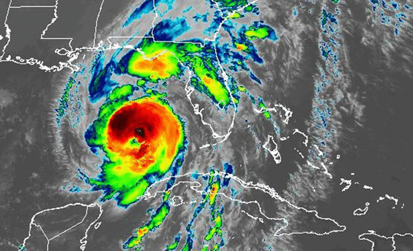
Hurricane Helene made landfall in Taylor County just after 11:10 p.m. Thursday as a devastating Category 4 hurricane, the National Hurricane Center said.
Gov. Ron DeSantis said the storm has claimed at least one life but the toll from the massive system will take days to assess.
Landfall capped a day that saw bridges closed, streets flooded and tree limbs flying as Helene — surging to Category 4 strength just hours before landfall — roared toward what is expected to be a catastrophic landfall. And with high tide still hours away for communities down south, the damage toll is expected to keep rising.
Power outages began to mount, particularly south of Tampa Bay, where by early afternoon some coastal cities like Sarasota and Tampa were seeing several feet of inundation in their downtown districts as the Gulf of Mexico surged inland.
A driver on a Florida highway died after Helene’s high winds blew a sign onto their vehicle earlier in the day, DeSantis said in a late night news conference.
At 9 p.m. Thursday, the National Hurricane Center said the rapidly intensifying storm was a Category 4 with 140 mph winds at its core. The massive system produced sustained winds topping 55 mph in the Cedar Key area and gusts as high as 64 mph reached as far as Hollywood earlier in the day.
By Thursday afternoon, conditions began to clear in the Florida Keys, where Helene’s surge inundated streets and submerged docks, as well as South Florida, where the tornado watch was lifted. Meanwhile, things continued to deteriorate further north.
Storm surge pushed tides three to five feet higher in Southwest Florida, and up to 8 feet higher in more northern areas like Cedar Key. In Clearwater Beach, seven feet of surge broke the previous record for the station by more than a foot.
Mandatory evacuations were called in 17 counties, sending hundreds of thousands of Floridians inland and away from potentially historic storm surge levels. FEMA and the state of Florida said they are ready for the storm, which will be felt through nearly the entire state.
Airports, universities and government buildings across the state were closed ahead of the storm. Large coastal bridges like the Skyway in Tampa began to close as winds picked up, and a fleet of bridge inspectors are set to examine them after the storm passes, Jared Perdue, secretary of the Florida Department of Transportation, said in a Thursday morning news conference.
DeSantis warned residents statewide to be prepared for power outages, potentially prolonged ones, despite the army of more than 30,000 lineworkers in place to start repairing the grid after Helene passes.
“We’ve got huge amounts of assets that are ready to go,” he said.
As of 10:30 p.m., about 780,000 utility customers were without power, particularly in Hillsborough and Pinellas County.
FEMA Administrator Deanne Criswell told reporters at the White House on Thursday that she plans to fly to Florida on Friday to survey the damage and meet with the governor and his team.
“We’re looking at where we think the biggest impact is going to be and right now it looks like it’s a dead-on hit to Tallahassee. And so we’ll fly as close to Tallahassee as we can get.”
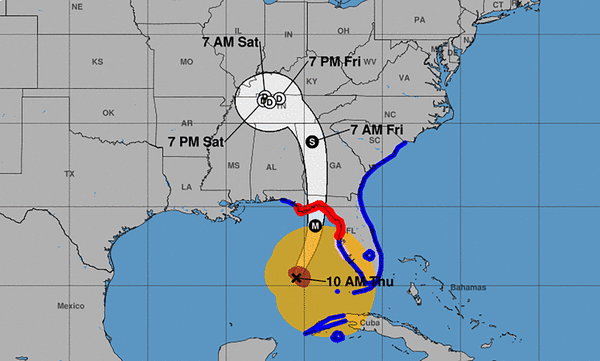
Despite small wobbles east and west, Helene’s center appeared pretty much dead center with the National Hurricane Center forecast track, as shown in a graphic created by Tomer Burg, a facilitator for the National Weather Service’s Weather Prediction Center.
“It is continuing to follow the forecast as expected and is not significantly deviating to the east,” he posted on X.
Helene is expected to bring massive amounts of life-threatening storm surge to nearly the entire Gulf Coast. Forecasters now expect up to 20 feet of storm surge above ground in the Big Bend area. But damaging levels will be felt further south, including up to 8 feet above ground in the Tampa Bay area.
The peak surge — potentially as high as a two-story building — is expected in Apalachee Bay. The hurricane center has repeatedly warned that totals like that are “unsurvivable.”
“Only way to ensure survival from surge like this? Don’t be there when it happens,” Rick Knabb, former director of the National Hurricane Center and now a hurricane expert for the Weather Channel, posted on X, the social media site formerly known as Twitter.
(Miami Herald Editor David Smiley contributed to this coverage.)
_____
©2024 Miami Herald. Visit at miamiherald.com. Distributed by Tribune Content Agency, LLC.


Comments