Tropical Storm Helene could hit Florida Gulf coast with 15 feet of surge as Category 3
Published in News & Features
MIAMI — Florida’s entire Gulf coast could feel the strong winds, intense storm surge and drenching rains of Tropical Storm Helene as early as Wednesday, with the strengthening system expected to slam somewhere along the Big Bend area less than two days later as a powerful Category 3.
The National Hurricane Center’s latest forecast for the system showed Tropical Storm Helene on track to enter the Gulf of Mexico, potentially brushing the Yucatan Peninsula on its way. From there, Helene is set to rapidly strengthen into a major hurricane before making landfall Thursday evening or early Friday morning.
On its current track, which could still change, the powerful core of the storm could cross directly over the state capital of Tallahassee.
But drenching rain and strong wind were expected to sweep much of the peninsula over the next few days. Hurricane and tropical storm warnings blanketed most of Florida’s west coast, all the way down to the Keys and inland to Orlando, and tropical storm watches cover most of the east coast. Gov. Ron DeSantis expanded a state of emergency to 61 of Florida’s 67 counties.
Mandatory evacuations began in counties near the Big Bend area, including Gulf and Franklin — where coastal communities could see 10 to 15 feet of storm surge potentially capable of flooding or destroying buildings and drowning people who fail to flee — as well as down south in Manatee and Charlotte County.
At a press conference Tuesday morning, DeSantis said the state has deployed Florida National Guard soldiers, search and rescue teams, the Florida State Guard members, and Florida Fish and Wildlife crews. Utility linemen are already setting up in strategic places across the state. Florida State University and Florida A&M University in Tallahassee also both announced they were closing campuses beginning Wednesday in advance of Helene.
FEMA has also deployed teams to Florida, along with resources like generators, food and water. And DeSantis said the state has requested a pre-landfall emergency declaration from FEMA, which unlocks aid and reimbursements for governments.
“For the state of Florida, we’ve turned on everything starting yesterday. We are rocking and rolling,” he said. “There is still some uncertainty, but I think the fact that this would be forecasted as a major (storm) without formation shows that this has a potential to be a really, really significant storm.”
Division of Emergency Management Director Kevin Guthrie said people should be preparing now and heed evacuation orders from local officials.
“The wind you can hide from,” DeSantis said. “But it is the water that can be very, very devastating if you remain there when you are told to evacuate.”
‘Life-threatening’ storm surge
Helene is set to be a very large storm, “nearly twice the size of Debby and Idalia, with possibly a stronger core,” Michael Lowry, hurricane specialist for WPLG-TV, posted on Twitter. The hurricane center noted Helene is expected to have a bigger wind field than 90% of other major hurricanes.
The wind field and rain bands from Helene are expected to stretch more than 140 miles east of the eye. That means the impact will reach far inland, Jamie Rhome, deputy director of the hurricane center, said in a briefing Tuesday morning. To put it simply, the next few days are expected to be mess for much of the state — and a potential disaster for areas near landfall and in the surge zone.
“It is going to be a big storm. And I mean big in terms of size, not intensity. Big storms cause big problems,” he said.
“The wind swath is going to be huge with this system, and it is basically going to carve a path right over a good portion of the Florida peninsula, including the highly populated I-4 corridor.”
The most significant threat from Helene, which is expected to be a broad, powerful, fast-moving storm, will be storm surge. A bigger storm moves more water ashore, raising the risk of house-crushing and life-threatening surge numbers.
Helene could bring storm surge to the entire west coast — up to 15 feet above the ground near landfall in Taylor and Dixie Counties, and up to 8 feet in the Tampa Bay region.
Combined with high amounts of rain in areas that are already soggy, like Southwest Florida, Helene will likely bring flooding. Six inches of rain could blanket the west coast, with up to 8 inches near Tampa Bay and the Big Bend area.
South Florida could start seeing several inches of rain and gusts of high winds as soon as Wednesday evening as the broad storm moves up the coast, spreading its impacts far east of the eye and inland of where it eventually makes landfall.
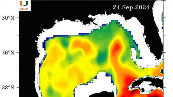
As Helene enters the Gulf of Mexico, forecasters expect it to rapidly intensify from a low-level tropical storm to an intense Category 3 hurricane in under two days. Conditions appear ripe for it — warmer-than-usual waters, low wind shear and other storm-friendly conditions pave the way for Helene once it enters the Gulf. The super hot waters of the loop current in the Gulf could help fuel its power.
As of the 5 p.m. EDT update, Tropical Storm Helene had 50 mph sustained winds and was about 150 miles south of the western tip of Cuba. It was headed west-northwest at 12 mph.
©2024 Miami Herald. Visit at miamiherald.com. Distributed by Tribune Content Agency, LLC.


Comments